I'm not a fan of Fishton, I certainly remember the epic battle between you, Doug and him. This would be the first time you have agreed with him on anything. I disagree with him also. Like I said, if the waypoints created using the 83khz, 60 degree transducer are inaccurate then the ones made using sidescan from 60ft away would be usless. In each case I don't create a waypoint without moving the cursor over the object, because you have already passed the object when it appears on the screen. I have created waypoints from 83khz, 200khz and sidescan (455 & 800khz) 60ft away and am able to go directly over those objects time and time again without any problems. If the waypoints created with the 83kz are not accurate, please enlighten me as to how they compare to waypoints created with sidescan, as far as accuracy is concerned.

-
Our new forum site is now live! If you already have an account you will need to reset your password before being able to access the site.
https://chattanoogafishingforum.com/index.php?lost-password/
If you don't receive the reset email don't hestitate to contact us: Forum Contact Form
You are using an out of date browser. It may not display this or other websites correctly.
You should upgrade or use an alternative browser.
You should upgrade or use an alternative browser.
A fire drill with Sonar, Down images.....(Pic Heavy)
- Thread starter Triton Mike
- Start date
It's about coverage area. 2D Traditional Sonar is cone shaped with each ping. 20 Degree sonar covers approximately 1/3 of depth so in 9 foot of water you have 3' of coverage. in 30' of water you have 10' of coverage get in deep water like 90 foot of water it's a 30' circle of coverage. Now with Dual Beam plus sonar this area of coverage increase to the same as depth. Some with the 60 degree beam in 9' of water you get 6' additional coverage outside the 20 degree beam for 9' of coverage. In 30' of water you have an additional 20' of coverage for 30' of coverage and in 90' of water you have an additional 60' of coverage or 90' of coverage. For Example if something shows up when scanning 30' of water in the 60 degree beam but not in the 20 degree cone it is from 11' to 15' to the side, forward, or behind the transducer. Since the beam is circular in pattern and grows as it gets deeper sonar cannot tell which direction it is in so there is no way to pinpoint the location. With the same accuracy as 20 degree cone with narrower area of coverage. This video shows the Area of Coverage and Dual Beam Coverage. http://www.youtube.com/watch?v=7TdKQyKkShk
Here's another video to help understand a sonar ping: http://www.youtube.com/watch?v=kELam6BWQcc
Since Side Imaging is a razor then beam the unit can calculate distance to the Sides because of the thin thickness (front to rear) the exact location can be pinpointed with Side Imaging and utilizing the Humminbird feature of moving the cursor over the point of interest and marking the location. Side Imaging is a totally different type of coverage area as can be seen in this clip: http://www.youtube.com/watch?v=XP0YwweZVOs features which Humminbird has patented technology on. You can search the Internet on these patents to learn more.
Triton Mike
New member
I hope nobody reading this thinks we are crazy LOL. I'm only continuing this discussion because I feel like people are learning from our dialogue. If it helps someone than it's worth it.
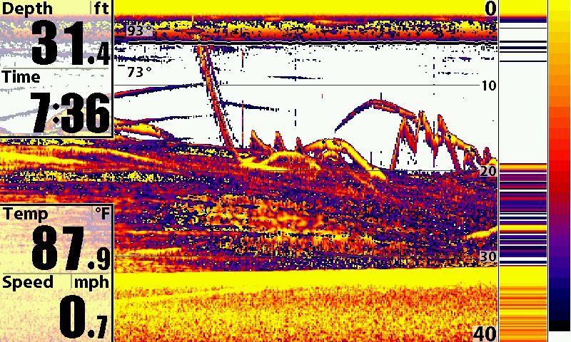
Norman, To further what Doug stated. Sonar is a CONE it has a circle for a footprint. It has no perception of left or right, frontwards or backwards. For instance. I have TWO brushpiles in this image below. How do I know this? I put them there and they are approx 15ft apart.. I want you to put your cursor on the LEFT one? Now do you understand? You can't put your cursor on the left brushpile because the sonar doesn't know left from right it lumps them both together on the screen because they are both in view of the sonar cone. Down Imaging works similiar.
Side Imaging knows left and right and that is why you can use the cursor effectively. Keep in mind I said MOST accurate GPS coordinates with 200khz. I didn't say you can't mark a brushpile in any other beam cone to mark brush because you can. If you happened to run over it with the 200khz cone in dual beam then yeah it will be accurate. If you run over a 30ft tree and mark a waypoint then yeah you have a good shot at being able to snag the tree with your spoon. But will you be fishing the trunk or the top of the tree? But if the structure is off to the side of the 200kzh beam then it will be off some.
Here is the sonar shot with TWO brushpiles in the sonar image. Which one is the left one and which is the right one? Or is one in front of the other?? You have no way of knowing with sonar..
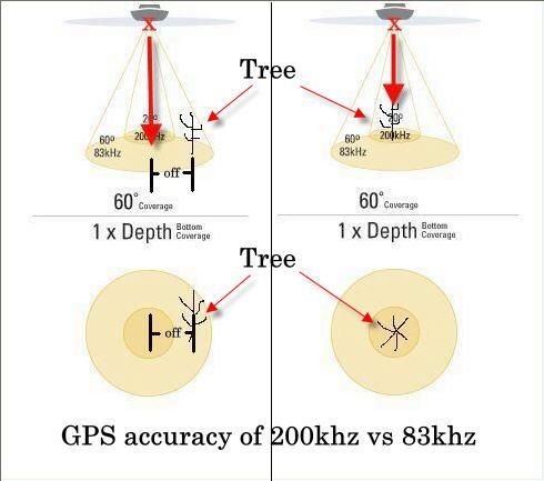
To further illustrate my point. You made the comment that the GPS marks the TOP of the water.
You are correct and based on that fact look at these diagrams. The RED X under the boat marks the GPS points. Both of these trees are within the cone beam and show up on your sonar. Which GPS point is more accurate? The one directly under the boat in the 200khz or the one off to the side??
Norman, To further what Doug stated. Sonar is a CONE it has a circle for a footprint. It has no perception of left or right, frontwards or backwards. For instance. I have TWO brushpiles in this image below. How do I know this? I put them there and they are approx 15ft apart.. I want you to put your cursor on the LEFT one? Now do you understand? You can't put your cursor on the left brushpile because the sonar doesn't know left from right it lumps them both together on the screen because they are both in view of the sonar cone. Down Imaging works similiar.
Side Imaging knows left and right and that is why you can use the cursor effectively. Keep in mind I said MOST accurate GPS coordinates with 200khz. I didn't say you can't mark a brushpile in any other beam cone to mark brush because you can. If you happened to run over it with the 200khz cone in dual beam then yeah it will be accurate. If you run over a 30ft tree and mark a waypoint then yeah you have a good shot at being able to snag the tree with your spoon. But will you be fishing the trunk or the top of the tree? But if the structure is off to the side of the 200kzh beam then it will be off some.
Here is the sonar shot with TWO brushpiles in the sonar image. Which one is the left one and which is the right one? Or is one in front of the other?? You have no way of knowing with sonar..
To further illustrate my point. You made the comment that the GPS marks the TOP of the water.
nwright - 8/3/2010 12:26 PM
Basically the GPS is marking the waypoint on top of the water, not in the water column.
You are correct and based on that fact look at these diagrams. The RED X under the boat marks the GPS points. Both of these trees are within the cone beam and show up on your sonar. Which GPS point is more accurate? The one directly under the boat in the 200khz or the one off to the side??
Glad to see you on this site, Doug. This may save me from having to run over to other sites to ask you and T-Mike annoying questions. LOL. Really, guys, thanks for all the help you have provided so far about these units. Your help in invaluable. The resent tips about mounting locations for the SI ducer have empowered me to try and mount it myself with some confidence that it is in the right place. Welcome.
Now do you understand?
Wow, I just thought I new how to use my equipment. Now I don’t have any “eye candy” to include with my replies so I’ll just have to stumble along without any.
I have a layman’s understanding of sonar and GPS technologies but I have managed to get by. Pinpoint accuracy is very seldom needed in a fishing application, but sometimes that is what I strive for. If it was that critical I would use the position averaging feature which was on some of the older units and is on my handheld units.
Many years ago when SA was turned on I used a differential corrections receiver to get three-meter accuracy. A company from California offered the service in Chattanooga so I bought their receiver and a lifetime subscription. They piggybacked their correction data on top of KZ106 FM radio. When SA was turned off the company went out of business and I was left holding the “bag”. Over the years I have owned 18 GPS and GPS/sonar units. I say all this so you will understand this “ain’t my first rodeo”.
I have never had a problem marking a waypoint from an object that showed up on my depth finder/sonar and going back to it and having it show up on my screen again. I have used 50KHZ, 83KHZ, 192KHZ and 200KHZ transducers.
I have no intentions of getting into a 25+-page debate, which happened between you, Doug and Fishton. It degraded rapidly into an ego feeding frenzy. Fishton was never to be seen again.
When I was gainfully employed I would go into a meeting and present data and statistics about a study I had done and people would question me about its accuracy. I learned if I put all that information in spreadsheets and charts no one would question me. Didn’t matter if it was factually true or not as long as I supported it with “eye candy”.
You all have a good day and I honestly have enjoyed the exchange.
emoSmile emoSmile
drdetroit
Member
I have another issue. When I ordered my boat the dealer talked me into a 997 on the console and a 797 on the bow. He told me I would have side imaging on both units. Well I only have side imaging on the 997 unit. Can you have side imaging on both units? If so what do I need to do to make it happen?
Thanks,
Dr Detroit emoScratch
Thanks,
Dr Detroit emoScratch
Doug V - 8/14/2010 8:52 PM
For Side Imaging Settings this Video Clip should help:
http://www.youtube.com/watch?v=YV-Rh8wXTY0
Whoa! That was the best one I've seen for dummies! Thanks!
Triton Mike
New member
Doctor, The 797 is not capable of SI or DI. You need the 798 to get SI.. Sorry to be the bearer of bad news.
The only Humminbird units that have Side Imaging/Down Imaging are
798Si
898SI
987SI
998SI
1197SI
1198SI
The only Humminbird units that have Side Imaging/Down Imaging are
798Si
898SI
987SI
998SI
1197SI
1198SI
If it has a Side Imaging Transducer on the Trolling Motor and the latest update the 797c2 can have SideImaging and Down Imaging. Humminbird was able to rewrite the code and get it to work on the 797c2. At first that didn't think it was possible but they did get it done. Make sure you have an SI Transducer and the unit set to Compact Si and latest update and you will have Si and DI.
All that makes perfect sense Mike and Doug. The tidbits to know how much bottom coverage at a given depth is a HUGE plus! No wonder I have missed so much of the stuff I have marked in the past. Hell, I had no idea where it was or which side of the boat to throw out of. I need to play with my settings and go out and find brush in an attempt to get a jig or something stuck in it so I can pinpoint EXACTLY where it is at. Thanks a ton guys! This is one of the most informative threads we have had on here in a while!
Triton Mike
New member
Doug V - 8/15/2010 7:52 PM
If it has a Side Imaging Transducer on the Trolling Motor and the latest update the 797c2 can have SideImaging and Down Imaging. Humminbird was able to rewrite the code and get it to work on the 797c2. At first that didn't think it was possible but they did get it done. Make sure you have an SI Transducer and the unit set to Compact Si and latest update and you will have Si and DI.
Brain fart on my end. I was thinking 787 duh!! Doug is right, Been a rough weekend
") .
.Heat getting to Mike??? Fully understand.
----
Since many commented on the Video Clip. I have a several clips on Humminbird with Trips and Tricks plus explaining some of the features:
http://www.youtube.com/user/imonbass
----
Since many commented on the Video Clip. I have a several clips on Humminbird with Trips and Tricks plus explaining some of the features:
http://www.youtube.com/user/imonbass
drdetroit
Member
What I have is the 797 c2 which has a label on the unit that says SI???? I do not have the transducer up front. It is on the transom and only shows up on the 997. The motorguide has the standard built-in transducer. When you go through the various screens on the 797 it has SI but there is only a blue screen. Do I still have hope???
Dr Detroit emoScratch
Dr Detroit emoScratch
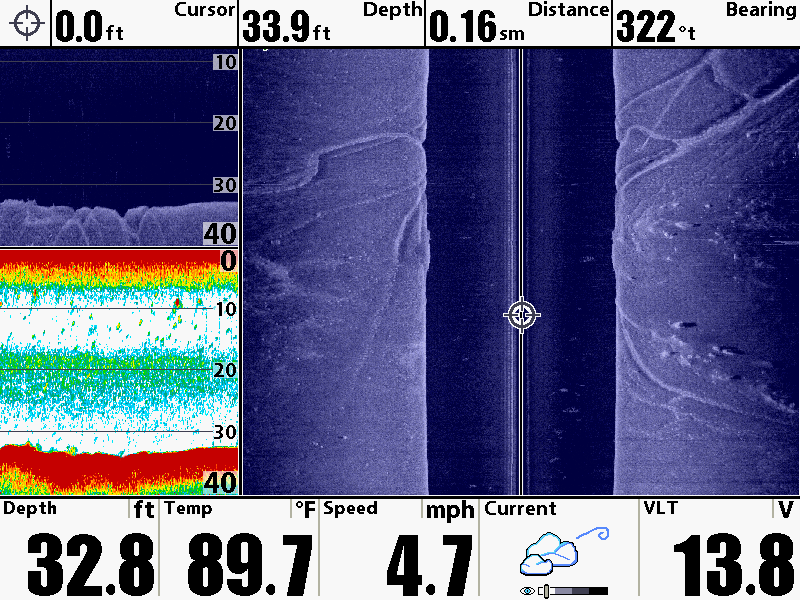
Since we have been talking about coverage areas of the different sonar...
Here is a great example where the Down Imaging and Side Imaging's very narrow - razor thin beam shows more detail than 2D Sonar. Look at these narrow ditches and you can see the depth in Side Imaging and Down Imaging but in 2D sonar the depth is not displayed due to the size of the coverage area. At the depths we are viewing 20° (200 kHz) coverage is approximately 11 foot or 1/3 of depth. Because these ditches are very narrow the 2D sound waves see them as flat - missing the details that Down Imaging and Side Imaging can show.
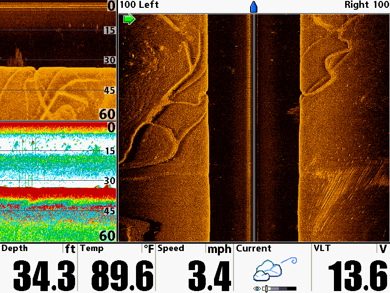
Here is a great example where the Down Imaging and Side Imaging's very narrow - razor thin beam shows more detail than 2D Sonar. Look at these narrow ditches and you can see the depth in Side Imaging and Down Imaging but in 2D sonar the depth is not displayed due to the size of the coverage area. At the depths we are viewing 20° (200 kHz) coverage is approximately 11 foot or 1/3 of depth. Because these ditches are very narrow the 2D sound waves see them as flat - missing the details that Down Imaging and Side Imaging can show.